2022-04-17T22:24:00Z New editing day has started, after doing the morning computer chores, shoveled down some food and now we are good to go for a full day of editing. Todays goal is to finish and release PMC Taiwan Kinmen terrain ![]()
So yesterday I found out that airfield runway smoothing went bad, airfield_runways.shp was present in the terrain processor road.shp shape, and that heightmap has some odd "line" between the satellite texture grid tiles.
Used GIMP to open all satellite texture grid tiles but could not find any visual indicator of why such odd "line" was left in the ocean shuffle work I did yesterday, hmm. Then scanned through all the Satellite.Mask/ XCF images too, nothing there either to suggest why that heightmap line appears in terrain builder, odd. Hmm.
In terrain builder inspected heightmap, the line appears close to kinmen airfield, just south east from it. Its between Sat_Tex_C2.bmp and Sat_Tex_C3.bmp grid tiles.
There is also odd satellite texture painting where one grid is ocean and another is ground, its one of those shitty areas where you cant really tell if the imagery is muddy water or ground dirt. These tiles are ground Sat_Tex_A3.bmp and ocean water Sat_Tex_A4.bmp images.
I could easily fix the heightmap oddity using L3DT, but its a fix not a solution, so you should always do a proper solution instead of patchy fixes.
First I used global mapper and deleted the roads.shp airfield runway poly line, this will fix the bad elevations on airfield when using terrain processor to smooth roads.
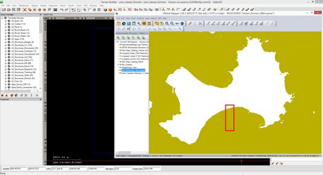
Opened global mapper project and My_Flattened_-3m_Ocean layer, found the issue there, illustrated in below screenshot:

Huh, wonder where that line came from as its not visible in any of the Satellite.Mask/ XCF images.
In global mapper found the heightmap line My_Ocean grid tile, but have no idea how that line got there. Inspected Sat_Mas_C2.png and Sat_Mask_C3.png where in between this line appears, but nothing out of the ordinary in global mapper, hmm really bizarre.
I think its time to get this thing done, going to just fix it in L3DT manually and be done with it, then road smooth in terrain processor and binarize, unless I spot anything else in arma3 check this terrain should be ready for release.
So did the heightmap edit in L3DT, exported heightmap.asc, set its ascii grid header to 200,000/0 and then ran terrain processor road smoothing on it. Next in terrain builder imported the new heightmap_smoothed_roads.asc and the line was gone. Exported WRP, saved project and exited.
WRP exported object count: 612,486.
2022-04-17T23:04:00Z Started pboProject binarization. This is fairly quick with low number of objects and only 40km terrain.
No time to waste, once binarize was chewing the WRP addon I already started release procedures.
Added pmc_taiwan_kinmen class name into PMC "worldSize" mission pack compilation bat terrain list so we can have some missions to play with.
2022-04-17T23:19:00Z Glad to see arma3 check has no more issues, heightmap line is gone and airfield runway is smooth as little girlie men terrain lovers butt ![]()
2022-04-17T23:41:00Z Screenshots taken, sorted, renamed, edited and converted.
2022-04-17T23:56:00Z Dev diary moved to its actual web page, proof reading and link adding started.
2022-04-18T00:19:00Z Finished proof reading dev diary, moved screenshots code to their final resting place, then started to do changelog page.
2022-04-18T00:32:00Z Uploaded web pages online, only few more steps left before release...
2022-04-18T00:38:00Z PMC Taiwan Kinment v0.1 has been released! ![]()
Continue reading page 4, previous page 2 or back to Dev Diary PMC Taiwan Kinmen root page.
PMC Taiwan Kinmen: Changelog, Dev Diary, Screenshots. Back to PMC Terrain's page.