hi all,
thanks for comments.
It looks awesome Luk. Very excellent work! Now for ODS or Iran????!!

he he... I would be happy I have time for it. But seriously - I can imagine, I will create X1 update map for mentioned theaters in quite near future.
It should look fine for desert scenarios. But we would substitute that dark brown mountain areas by something less agressive first...
The problem is, I have some fresh architectural/civil eng. tenders, so I will be snowed under "real life work" some next months

Can it be used in FF or OF theaters?
I am sure the terrain format is also usable for FF + OF. But I did never test X1 colouring in mentioned subversions (in case it is not visible -still no huge problem IMHO).
The main problem are used tiles. This is about "politics" a little bit. It is something what broked my passion in last years. Then I did decision to use AF (hitiles) tile codeing (the most complete set IMHO). But I alive how problematic this decision is.
I think Tom D. Wälti has given permition to use some low-ress version of his tiles in Panama theater. In case somebody "diplomatically clever" will negotiate something similar for EU, it would be fine.
I think Panama is for FF/AF/OF - in that case it should have both PCX + DDS maps..

?
I firstly thaught, we will distribute it with slightly changed standard AF textureZIP(+ user can change to any season hitiles at home). But this is still AF only approach (

).
BTW - even pure/default AF texture ZIP/Bin - although compatibile- it is still problematic. I have tested it. It strongly narrows down the number of possibly used variation tiles. Some tiles have different numbers, some tiles are missing.
There is also another approach - to collect some free hi-tiles texture-zip + replenish it with some new texture sets. But it is something I like to avoid. Mind you - to paint a texture is not problem for me, but texture bin/paths edits...it is another/next pandora-box oppening

. We need working campaign. It is the main task now. So we should use something allready tested.
And why I need to replenish it? It is because, the cityrivers are missing in free ZIPs. But I can be wrong. In case you will show me some complete free ZIP(...slopes-called trees,rocks, snow, highways, cityrivers), I can modify configs.
I have also tested different seasons. It also narrowed down the number of variations. I can say, hi-tiles textures are not seamless at all. In case of "slopes", there are only the "trees" tiles (1239 + surrounding tiles -named trees in TV) seamless to forrest in winter.
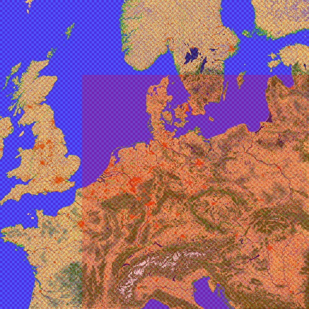
here an exaple of this tileset. I hope you can recognize it in this lores image (located nearby some lower mountains in Slovakia)

say, i think the "europe-feeling" mostly counts on dedicated tiles..since you master CATE coding, maybe adding more tile variants?
As I wrote above. Despite I have some thaughts and tips for new textures, I will rather finish CATE tiled terrain and then focus on hand fixes/updates + working campaigns.
I know I will rue rest of my life, I did not added at least 1 tile variation for each straight river direction. But I mast learn to live with it.
BTW - I have small tip, I have learned during hand-tiling. In case of very long and straight river segment , there is a possibility to lower repeating pattern.
It is possible to add a little affluent there and there. Or to make small forret, etc. Some of the "effects" would be probably possible to add automaticaly (Phoenixs ATAP program ?). I will do it probably by hand (ATAP just for some additional coast variations - but I did not test it yet).
my humble terrain experience shows.. ( i knew SM has detailed wiki)
- DEM terrain build first.
- use a map bmp, run CATE to tile.
- then generate THR file. use THR file in TacEdit to help obj-linking.
so.. this ongoing terrain update is at 2nd step..right? If you plan to introduce more tile variants (massive workload), then this step will last for a while.
I have realized during the last year, that the best way to mod F4 for me - is to work on terrain + CAM at the same time. So I am updating my thr all the time. I can place the objective in terview + fix /create the road imediately (just ALT-TAB switching).
btw have you made also new tiles or is it just about the correct placement?
keep them coming!
Its just about tiling.
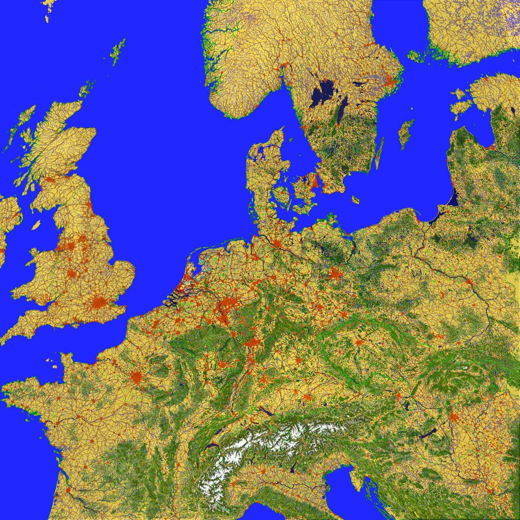
Truly monumental project. And it looks very good considering that all tiles were placed auto. Even rivers are in the lowest points of the valleys. I hate when the river runs higher than road tiles.
I also hate "roller coaster" rivers in theaters. Bu I can not to do many in it. I have just hided hill top rivers (ice border) under the rocky tiles and some other buggy rivers under the lake tiles. But I can not influence other river features.
I use the original PMC road-river tdf data file for features. I just replenished it with Kaliningrad area (previously missed).
I have some idea, how to make all rivers nice. But I need to discovere, how to update terrain highs from external highmap file.
It is theoretically doable with older BaldEagle's utilities. But I can not work with them. These utils must be setted according to some registry/active theater? entries etc. to work...(not very friendly for users such me
)
But what about BAZT utils? There is a DAT file for hi-res high map. There should be some easy way, how to convert DEM geotiff or another DEM highmap to useable file already discovered! Perhaps Photoshop can save it as well setted raw, which is just lately renamed to DAT ??!!!
Imagine it - dedicated greyscale image for all leveling changes! Help please.
I can see also the next advantage of such solution. I will explain it.
Pure SRTM data update is not good choice in my opinion. It is because of F4 1,5 square mile nature. SRTM can never match Falcon patterns + there are some aditionals object placement problems, radar cover files etc. But what about "quasi SRTM" terrain? There is a free util in internet, it can count erosion for bitmap. So in case u will take default L2 resolution map with fixed river patterns, you can make high resolution terrain just for Falcon world (it did not match the real world of course, but who care about 300-800 m inaccuracy, appearance is important here).
Just a short conclusion:
1.we should discuss used texture zip (but Tom's agreement is the best way

lores as deffault, high res at home for hi-tiles owner )
2. I need to finish BMP for whole map, then make 2 missing BMP passes - 1st for highways, 2nd for river lowering (in case we will fail to handle that mentioned external highmap)
I will be very happy to have some fixed CATE version for it, but it is for another topic...
3.configure ATAP program and replenish terrain with some complex patterns
4. Hand out areas for particular campaigns, then place real used ABs + squads and some important objectives by hand there. Then to fix linking + adjust some values by hand (acceleration/deceleration of units). Mind you, despite of CATE unpredictability I still preffer this program for most things, but in case you will place AB by CATE, you should also connect it to road system.
I hope you can understand me, I can not find proper words sometimes.
Luk


