Terrain / Theater editing
Moderators: Lone Wolf, Snake Man
-
Blueprint
- Recruit
- Posts: 39
- Joined: 2007-02-28 19:17:58
Post
by Blueprint » 2007-04-07 15:47:48
After 107 mins processing time and 200 MB memory usage:


Tutorial to come in a few days.
-
Snake Man
- Commander-In-Chief
- Posts: 9354
- Joined: 2000-07-31 22:01:01
- Gaming Interests: ArmA, ArmA 2, Falcon 4.0 and OFP.
- Editing Interests: All, I (try) to edit everything.
- Location: PMC
Post
by Snake Man » 2007-04-07 16:00:39
What kind of CPU was used?
Does the tutorial mean that all the data is available from the net and you just give tutorial + utility to proccess the data or do we have to get the data also from you?
Excellent work so far!
-
Blueprint
- Recruit
- Posts: 39
- Joined: 2007-02-28 19:17:58
Post
by Blueprint » 2007-04-07 16:23:26
CPU was a Venice 3200+ @ 2.5 GHz. The memory-friendly projection version is very file system intensive which is the most limiting factor.
While the SRTM data is available from a NASA ftp, it's a pain to download all needed files and then also face the risk of having holes in the mesh. I have the entire 40 GB dataset at my disposal which has those problems repaired by interpolation from the SRTM-30 dataset. So the process of creating the SRTM theater terrain file will be my job.
I will hand out an installer and corresponding data for every theater.
There is one extra tool I'm going to release. It converts the theater's objective data into a BaZT readable format.
-
ccc
- Chief of Staff
- Posts: 4857
- Joined: 2000-08-06 22:01:01
Post
by ccc » 2007-04-07 16:38:46
WOOOOOOOOOOOOOW.. you the MAN!!
Great job. 8)
-
ranger822
- Banned user
- Posts: 389
- Joined: 2004-07-27 22:01:01
- Gaming Interests: Falcon 4.0
- Editing Interests: All, I (try) to edit everything.
- Location: Beautiful Virginia
Post
by ranger822 » 2007-04-07 16:41:54
ahhhmmmm - I just crapped my my pants - that is the most beautiful terrain I have ever seen. . . .
When can we get our hands on this? CCC - - are you salivating as much as I am?
I am curious what does the white stuff on the map represent?
-
ccc
- Chief of Staff
- Posts: 4857
- Joined: 2000-08-06 22:01:01
Post
by ccc » 2007-04-07 16:54:31
ya i am curious about those white color area.. missing terrain data?
-
Blueprint
- Recruit
- Posts: 39
- Joined: 2007-02-28 19:17:58
Post
by Blueprint » 2007-04-07 16:59:34
The white color shows roughly the coast line of the original theater L0.
-
ranger822
- Banned user
- Posts: 389
- Joined: 2004-07-27 22:01:01
- Gaming Interests: Falcon 4.0
- Editing Interests: All, I (try) to edit everything.
- Location: Beautiful Virginia
Post
by ranger822 » 2007-04-07 17:08:47
OK - looks like a lot of terrain was missed!
Blueprint - I don't know how to thank you - what a wonderful gift.
I am still not giving up entirely on SRTM for Israeli Theater. I have got to track down Dudi.
-
i_hawk
- 2nd Lt
- Posts: 89
- Joined: 2007-01-17 07:10:34
- Location: Israel
Post
by i_hawk » 2007-04-07 17:29:50
Really amazing stuff Blueprint


G-byte Nforce3 ultra,AMD 64 bit 3000+ 939 OC'ed to 2.25GHz, 1024MB 400 MHz CL 2.5 on dual channel , RADEON 9800 pro
-
lamurt
- Recruit
- Posts: 46
- Joined: 2002-04-11 22:01:01
- Location: izmir, Turkey
Post
by lamurt » 2007-04-07 17:59:02
mmmm.....
flying in and out of those valleys.....
mmmm

thank you

-murad
-
Blueprint
- Recruit
- Posts: 39
- Joined: 2007-02-28 19:17:58
Post
by Blueprint » 2007-04-08 11:25:03
For the falklands installer I need the following theater files:
- falcon4.ocd
- falcon4.fed
- objectives.csv from a TacEdit objective export of the TE file that holds all the theater's objectives
-
Blueprint
- Recruit
- Posts: 39
- Joined: 2007-02-28 19:17:58
Post
by Blueprint » 2007-04-10 18:07:57
Israeli theater

-
i_hawk
- 2nd Lt
- Posts: 89
- Joined: 2007-01-17 07:10:34
- Location: Israel
Post
by i_hawk » 2007-04-10 18:40:45
G-byte Nforce3 ultra,AMD 64 bit 3000+ 939 OC'ed to 2.25GHz, 1024MB 400 MHz CL 2.5 on dual channel , RADEON 9800 pro
-
ranger822
- Banned user
- Posts: 389
- Joined: 2004-07-27 22:01:01
- Gaming Interests: Falcon 4.0
- Editing Interests: All, I (try) to edit everything.
- Location: Beautiful Virginia
Post
by ranger822 » 2007-04-10 19:52:07
well CCC - it looks like my guess was correct

Second - THANK YOU BLUEPRINT, THANK YOU, THANK YOU, THANK YOU!
However, I notice right away when comparing the BMP that is generated by TerrainView for viewing in Tacedit - there is a bit of a discrepancy between SRTM and DEM - - I have made a composite - a red overlay of the water from DEM map on top of the SRTM - you can see the differrence in size - I think we have the correct center coordinates - but the terrain is slightly different - - Red Sea is slightly angled - also the northern part of Israeli and most of the area of land is actually a little bigger - - also what happend to Cyprus in the north part of map? It isn't a big issue but never the less it looks like we have some homework to do to get SRTM terrain 100% looking good and matched up with our objectives - - my guess is coastline cities and airbases will appear further inland if we place land tiles where the SRTM has elevation above sea level.
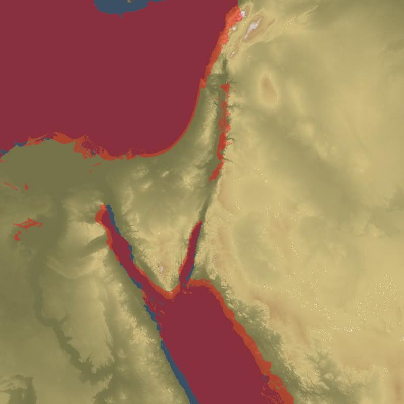
Makes me think we may need to look at having to make some adjustments - maybe handtile or retile - since Dudi did Israeli Theater by hand (YIKES) there won't be any CATE files to reuse.

However, before we get too whacked out lets just take a look at what SRTM looks like when we run it all the way thru - - and install and fly. Maybe it is no big difference? Problem will be the coastline discrepancy.
I wonder if we can make adjustment in Terrainview with the BaZT terrain or if we have to retile areas to fit the elevations in BaZT?
-
Snake Man
- Commander-In-Chief
- Posts: 9354
- Joined: 2000-07-31 22:01:01
- Gaming Interests: ArmA, ArmA 2, Falcon 4.0 and OFP.
- Editing Interests: All, I (try) to edit everything.
- Location: PMC
Post
by Snake Man » 2007-04-10 20:14:09
Could that be the spherical conversion of Dem2terrain?
-
Blueprint
- Recruit
- Posts: 39
- Joined: 2007-02-28 19:17:58
Post
by Blueprint » 2007-04-10 22:08:29
Now this is interesting! I'm gonna have a try applying the same projection to globe data and compare the results.
-
Snake Man
- Commander-In-Chief
- Posts: 9354
- Joined: 2000-07-31 22:01:01
- Gaming Interests: ArmA, ArmA 2, Falcon 4.0 and OFP.
- Editing Interests: All, I (try) to edit everything.
- Location: PMC
Post
by Snake Man » 2007-04-10 23:31:26
Ah shit no wait! I just remember, the dudi death_119 guys Israel theater is NOT spherically converted as its the age old ancient L2, unless the ranger822 & gang has redone the L2 (which I think they didn't).
I mean I'm 99.9% sure deaths L2 is NOT spherically converted.
-
ranger822
- Banned user
- Posts: 389
- Joined: 2004-07-27 22:01:01
- Gaming Interests: Falcon 4.0
- Editing Interests: All, I (try) to edit everything.
- Location: Beautiful Virginia
Post
by ranger822 » 2007-04-11 00:03:40
Right Snakeman - we haven't touched the L2 except for leveling airbases.
So, whatever we had to start with is what we have now -- does this mean we are not a candidate for SRTM too?

The alternative is we would have to rebuild israeli theater from scratch and totally retile?
-
Blueprint
- Recruit
- Posts: 39
- Joined: 2007-02-28 19:17:58
Post
by Blueprint » 2007-04-11 08:35:28
If the data is in its geographic form, it should be possible to create data for it as well.
-
Blueprint
- Recruit
- Posts: 39
- Joined: 2007-02-28 19:17:58
Post
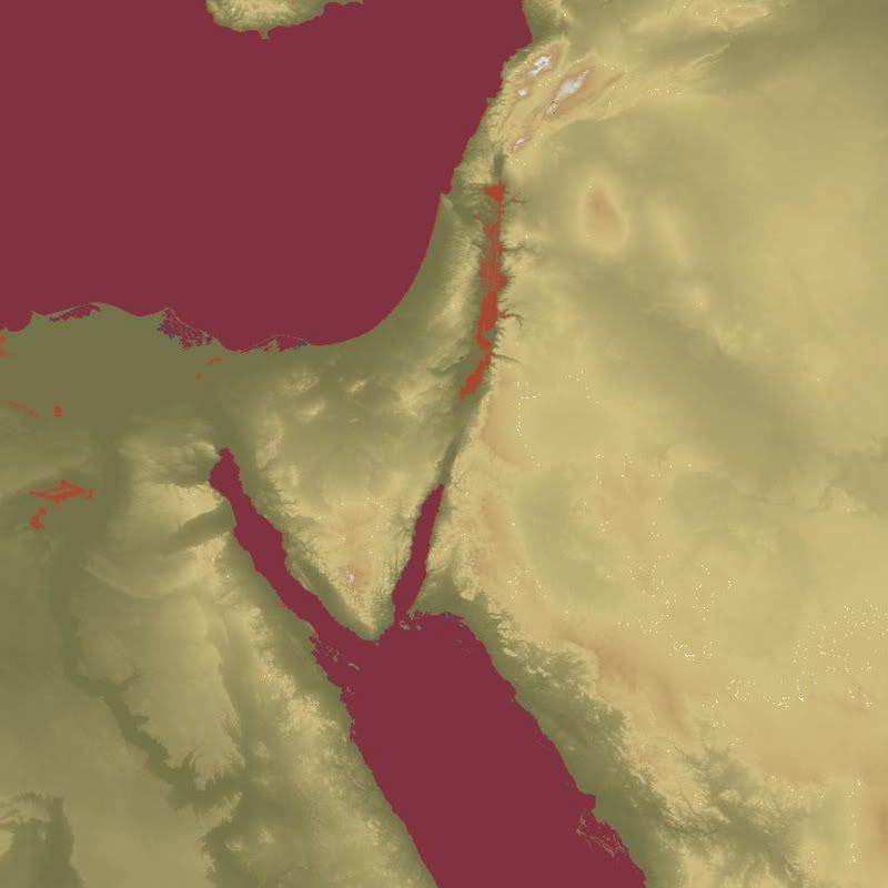
by Blueprint » 2007-04-11 11:16:59
Israeli theater (geographic)

-
ranger822
- Banned user
- Posts: 389
- Joined: 2004-07-27 22:01:01
- Gaming Interests: Falcon 4.0
- Editing Interests: All, I (try) to edit everything.
- Location: Beautiful Virginia
Post
by ranger822 » 2007-04-11 11:38:32
Blueprint - that is a perfect match for the old terrain. How do we make use this SRTM data you made? Do I need to send you anything or do I need some update to the installer you sent me?
-
Blueprint
- Recruit
- Posts: 39
- Joined: 2007-02-28 19:17:58
Post
by Blueprint » 2007-04-11 12:51:05
I'll send you a new package later today with the geographic data.
-
Snake Man
- Commander-In-Chief
- Posts: 9354
- Joined: 2000-07-31 22:01:01
- Gaming Interests: ArmA, ArmA 2, Falcon 4.0 and OFP.
- Editing Interests: All, I (try) to edit everything.
- Location: PMC
Post
by Snake Man » 2007-04-11 14:24:40
Geographic data... I'm dumb, guys please draw me a picture here, was I right, is Israel L2 made with perl scripts ie non-spherical?
-
ranger822
- Banned user
- Posts: 389
- Joined: 2004-07-27 22:01:01
- Gaming Interests: Falcon 4.0
- Editing Interests: All, I (try) to edit everything.
- Location: Beautiful Virginia
Post
by ranger822 » 2007-04-11 15:16:31
Thanks Blueprint . . .
Last edited by ranger822 on 2007-04-12 13:18:32, edited 1 time in total.
-
Ronen_101
- Newbie
- Posts: 1
- Joined: 2005-06-19 22:01:01
- Location: Israel
Post
by Ronen_101 » 2007-04-12 08:56:35
I think the time im gona spend on that Add-on has just climbed
Ranger , whats up ? : )
Congrats for your team on the great release , you did an amazing job .
-
ranger822
- Banned user
- Posts: 389
- Joined: 2004-07-27 22:01:01
- Gaming Interests: Falcon 4.0
- Editing Interests: All, I (try) to edit everything.
- Location: Beautiful Virginia
Post
by ranger822 » 2007-04-12 13:02:24
Preliminary tests are good - Here is a Beta NSIS installer which should make everything a one-click. Will post a link at Israeli Theater downloads. It was a really dirty NSIS script - bare bones. Should work for ALL exe types . . . again HUGE THANKS to Blueprint - master of the universe!!!
If it works we can find an FTP to upload permanently - right now I couldn't seem to get medifire to upload it. So, I went with Yousendit. I didn't try get fancy and make an uninstaller - if someone wants to really jazz it up let me know I will send the script I used and they can take it from there.
http://download.yousendit.com/8B5BCB4861B1EEC1
-
ccc
- Chief of Staff
- Posts: 4857
- Joined: 2000-08-06 22:01:01
Post
by ccc » 2007-04-12 14:37:05
GREAT JOB.
i test it in YKW campaign, the SRTM terrain looks great over death sea coast/syria-lebanon moutain areas.
a must have for ITO2!! 8)
now i am truely drooling at theaters have spiky moutains..taiwan, indea-pakistan boder, iran inland.. etc!!
-
T_Rex
- FreeFalcon
- Posts: 848
- Joined: 2001-03-04 23:01:01
- Location: here
Post
by T_Rex » 2007-04-12 18:14:59
Heya Bluey-
Not to bring up a sore subject, but any chance of an SRTM Korea for RV?
(Nothing ventured, nothing gained.)

Sic Semper tyrannosauro.
-
Zaggy
- Colonel
- Posts: 380
- Joined: 2001-07-09 22:01:01
- Location: AU
Post
by Zaggy » 2007-04-13 18:11:47
Snake Man wrote:Geographic data... I'm dumb, guys please draw me a picture here, was I right, is Israel L2 made with perl scripts ie non-spherical?
When Bluey says Geographic Data, he means a 'Mercator projection', where the dataset is projected in a way where all longitude lines are parallel; same kinda projection as the original Korea Theater...
In short, the terrain uses the RAW data, and doesnt spherically convert.
Daniel "Zaggy" Bell
Old-School, Grumpy and Anti-Social
Also to be found lurking round FighterOps
-
ccc
- Chief of Staff
- Posts: 4857
- Joined: 2000-08-06 22:01:01
Post
by ccc » 2007-04-14 17:14:42
out of curiosity.. has any SRTM request for ODS/Iran/Afghanstan being sent to Blueprint?
my recent test in SRTM israeli shows SRTM do great job at moutaneous areas, the flat desert may not show big differences.
-
Sherlock
- Lt. General
- Posts: 1167
- Joined: 2006-05-24 22:01:01
- Gaming Interests: Falcon 4.0
- Editing Interests: All, I (try) to edit everything.
- Location: Arizona, USA
Post
by Sherlock » 2007-04-14 18:54:08
ccc wrote:out of curiosity.. has any SRTM request for ODS/Iran/Afghanstan being sent to Blueprint?
my recent test in SRTM israeli shows SRTM do great job at moutaneous areas, the flat desert may not show big differences.
Snake Man and I discussed the Iran theater but we are holding off submitting for SRTM update because the objectives may change. When we are sure of the objectives we will submit for SRTM to Blueprint.
Sherlock
Victurous te Saluto
-
marvin157th
- 1st Lt
- Posts: 128
- Joined: 2004-07-28 22:01:01
- Location: Saskatoon, Sk Canada
Post
by marvin157th » 2007-04-15 09:58:23
Afghanistan would have to be a must since it is probably 80% mountains. Something like this would really help bring that theater to life.
Jody
-
Closter
- Captain
- Posts: 154
- Joined: 2007-01-07 00:13:42
Post
by Closter » 2007-04-15 22:39:54
Sherlock, it is not necessary to wait for the objectives to be frozen. You can remake the flattening in the installation process with Blueprint's tool, AFAIK, in
this sticky it is said. So you can change your objectives anytime along the creation process, because the basic terrain is the same, it doesn't need to be redone. Above he (Bluey) said the files that are needed.
It would be cool a next PMC theater with SRTM built in the installer, but please, make L0 and L1 install optional.
-
Buzzz
- Newbie
- Posts: 1
- Joined: 2006-01-10 23:01:01
- Location: France
Post
by Buzzz » 2008-01-10 12:40:17
Zaggy wrote:When Bluey says Geographic Data, he means a 'Mercator projection', where the dataset is projected in a way where all longitude lines are parallel; same kinda projection as the original Korea Theater...
I have a question.
I'm trying to convert the falcon coordinates for an external acmi tool and I would like to know if the projection for the old theaters is a mercator projection or transverse mercator projection.
Can someone tell me?
-
Closter
- Captain
- Posts: 154
- Joined: 2007-01-07 00:13:42
Post
by Closter » 2008-01-10 17:40:21
I don't know exactly the answer, but if you can tell the difference between Mercator and Transverse Mercator, then I bet you can understand what it means geographic projection:
X. Longitude in degrees
Y. Latitude in degrees
Full stop.
You only need a reference, a coordinate origin for the land extension you want to project, and the point over earth's surface is correlated with a point over a rectangular grid by the value you set, e.g. 30 arcsec = 1 pixel.
This kind of projection is bad, ever, but worst in high latitudes and big extensions. So Mercator scales with latitude, trying to reduce deformation.
The geographic projection was chosen in primary theaters, I guess, because source data is in that format too. The next 128 theaters were that badly deformed that it triggered the writting of dem2terrain and the use of the so called "spherical projection" (could be named spherical correction instead).
Who is online
Users browsing this forum: ClaudeBot [Bot] and 0 guests