Page 1 of 1
FS22 Minnesota Argyle 7km
Posted: 2023-03-30 19:08:07
by ARG_Afb
hey snake! i have seen that you said 1 meter precision heightmaps are available, and wanted to make a map, so i wondered if you could get me some data for a map in minnessota, this is the location:
https://www.google.com.ar/maps/@48.3843 ... a=!3m1!1e3
Re: FS22 Minnesota Argyle 7km
Posted: 2023-03-30 19:09:27
by ARG_Afb
i would like the map to be 8.1x8.1 km
Re: FS22 Minnesota Argyle 7km
Posted: 2023-03-31 01:33:11
by Snake Man
Been busy mondays through fridays, but saturdays and sundays I have some time so could try to get it done, cant make any promises though.
Also please select some nicer size than 8.1km as its been done to death because lack of community knowledge that any sizes are available, maybe 7.1km? 9.2km? etc.
I could also use object placement help with PMC Ohio Alger 10km, maybe we could come to some arrangement with that, just a thought.
Re: FS22 Minnesota Argyle 7km
Posted: 2023-03-31 11:13:25
by ARG_Afb
thanks snanke! its ok, hope you can rest a bit from work... yeah its hard when you have lots of things to do, another size.... hmmm.... maybe... yeah 7 km! thats a fantastic idea snake!

again thanks for getting this files for me!
Re: FS22 Minnesota Argyle 7km
Posted: 2023-03-31 11:14:27
by ARG_Afb
yes of course i can help you with the Ohio Alger map! just tell me what to do and i will do it!
Re: FS22 Minnesota Argyle 7km
Posted: 2023-04-02 04:33:54
by Snake Man
Okay global mapper project created for the area, adjusted center X slightly to the west from the google/maps linked intersection to catch few nice farm yards in the west edge by the river.
USA Minnesota Argyle 7km Design 1.
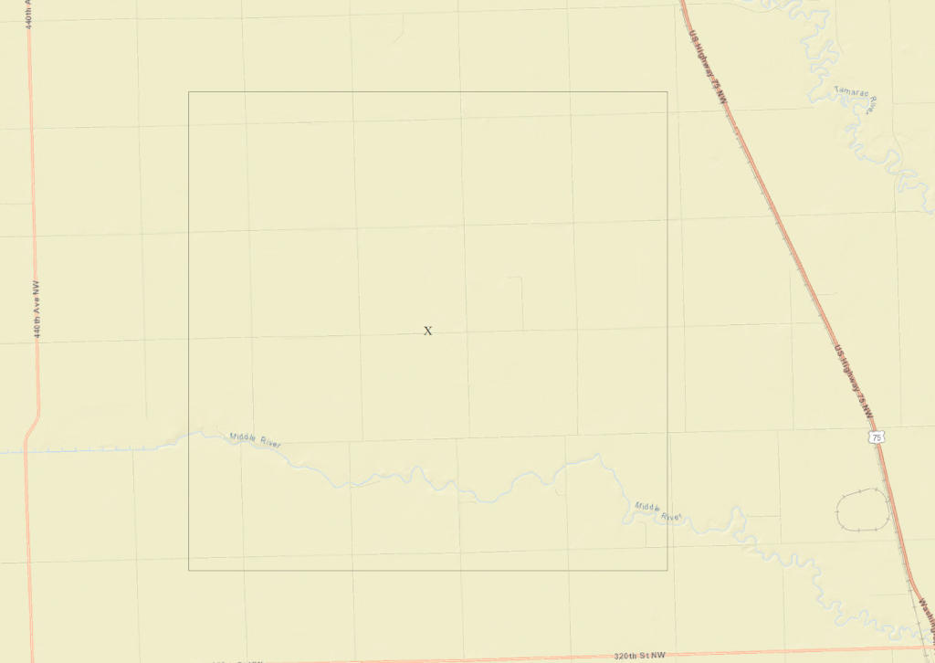
How does that look, edges all OK, size OK?
One issue though, I plotted the project as heightmap 4096 x 4096 grid so unitsPerPixel would be 1.75m, now this is slightly less than giants default 2m plus its larger heightmap than what giants use (2048 x 2048), in PMC Super Six 6km I used 4096 x 1.5m and it caused performance issue when looking at the center of the terrain from the edges with much of the horizon on the screen, so I had to revert down to 2048 x 2048 heightmap which removed any performance issues (but, obviously doubled the unitsPerPixel, meaning how much details can heightmap hold). I have no idea if 4096 x 1.75m is lag free or not.
If there is a performance issue, next step down is 2048 x 3.5m.
Checked out nationalmap.gov for high resolution heightmap availability, unfortunately 1m resolution is not on this area, you only get 1/9 arc second which is about 3.4m details. I don't know if road ditches can be done using 3.4m resolution, never tried it. If you wanted to enjoy the luxurious 1m heightmap data details, then you need to find a location on nationalmap.gov with 1m data vailable.
With PMC Ohio Alger 10km I found the ohio state .gov website to download 1m resolution heightmap data, dunno if there are similar for minnesota. Unfortunately that would be your job to google it up, I simply cant devote such resources from my sunday on that.
Once design coordinates are locked in, I can do that 3.4m heightmap data terrain source files today sunday. If you find me easy to download minnesota state website high resolution heightmap source then yeah 1m can be done as well.
Word of warning though, if this project slips to monday... then the next time I can work on it is on the next weekend again. I'll be waiting for your reply today.
Re: FS22 Minnesota Argyle 7km
Posted: 2023-04-02 12:13:55
by ARG_Afb
hey snake! yes thats ok, that level of precision is good!
Re: FS22 Minnesota Argyle 7km
Posted: 2023-04-02 14:13:26
by Snake Man
Just tried to download US NAIP and heightmap data, the nationalmap.gov website is giving JSON error, its not working. Do you want me to download US NED 10m resolution heightmap and ArcGIS world imagery satellite texture, or wait that the website is fixed?
Re: FS22 Minnesota Argyle 7km
Posted: 2023-04-02 16:06:32
by ARG_Afb
yeah NED and arcgis are ok
Re: FS22 Minnesota Argyle 7km
Posted: 2023-04-02 17:04:33
by Snake Man
Changed this topic title to fit the proper terrain name. Just sent you private message with the link to download. Here is your heightScale:
Once you start to paint cultivator_density on top of the ArcGIS satellite imagery, its usually not 100% fitting the better US NAIP source. Are you sure you don't want to wait until higher resolution better quality source become available?
Anyways if there was nothing else, KTHNXBY! and see you next weekend

Tags: Farming Simulator 22, FS22, american map, big american map, Argyle, FS22 american maps.
Re: FS22 Minnesota Argyle 7km
Posted: 2023-04-02 17:14:12
by ARG_Afb
imagery is perfect! thanks snake!
Re: FS22 Minnesota Argyle 7km
Posted: 2023-04-10 19:27:33
by ARG_Afb
map "finished" as i wont release it, experimental maps wont get released till december 2023
Re: FS22 Minnesota Argyle 7km
Posted: 2023-04-10 23:56:07
by Snake Man
Finished, you mean everything done, object placement, placeables.xml and all?
What happens in december 2023?
Re: FS22 Minnesota Argyle 7km
Posted: 2023-04-11 18:32:00
by ARG_Afb
im gonna release a lot of maps in december