Page 1 of 1
dem2terrain
Posted: 2002-04-29 15:15:00
by codec
Yes - a new kid on the block of theater production. This utility does much of what the program dem2lf that Miran Klemenc produced.
It takes the DEM data found on the nasa site
Nasa Dems
applies spherical conversion and allows you to select an area. I think it does most of what dem2lf does, and a few other things into the bargain.
Produces L2/O2 data format from DEM's (spherically corrected)
Process E00 data files for airport, road, drainage, coast lines, railways and towns, with preview picture.
Will produce .TDF files from this data
Will produce .MEA file from the data
Will produce .MAP file from the data
Will produce .TXT file with description of theater in
Will produce small or large format L2 data.
Supports different theater sizes and resolutions
User configurable colour and output display
Preview window
Can load several theaters at the same time.
This is the first public release, the 1.6 version of it. We may be adding further to it as time goes on.
It is reported to be considerably faster than dem2lf, by
days in the case of chinese rivers.
I'd like to thank Miran Klemenc for the dem2lf, which has been the mainstay of theater development for over a year now. The great think about these developments is the ability to build on the ideas of others.
Julian.
Re: dem2terrain
Posted: 2002-04-29 15:28:00
by Snake Man
Re: dem2terrain
Posted: 2002-04-29 15:43:00
by ccc
cool. just cool. can it handle higher latitude area?
Re: dem2terrain
Posted: 2002-04-29 17:00:00
by Snake Man
quote:Originally posted by ccc:
cool. just cool. can it handle higher latitude area?
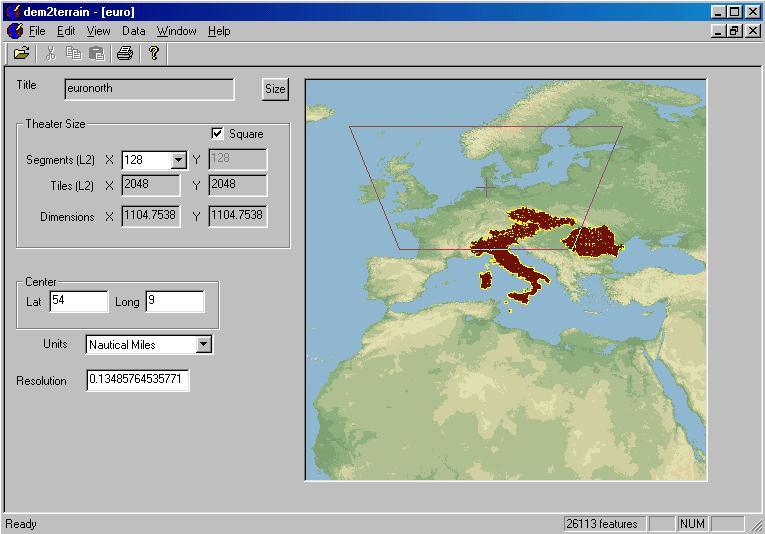
Theater name: alaska3
Theater size: Regular
Size (L2 segments): 64 x 64
Size (L2 tiles): 1024 x 1024
Size (Nautical Miles): 552.377 x 552.377
Resolution: 0.134858 Nautical Miles
Centered on: Lat 71 Long -159
NW: Lat 75.6031 Long -177.514
NE: Lat 75.6031 Long -140.486
SW: Lat 66.3969 Long -170.496
SE: Lat 66.3969 Long -147.504
Highest point: 7639ft
Lowest point: 0ft
Above example works good.
PMC TFW
Snake Man
Re: dem2terrain
Posted: 2002-04-29 17:27:00
by Alberto
Hi Codec
I only have one word: EXCELLENT!
Many thanks for this software
Saludos
Re: dem2terrain
Posted: 2002-04-30 07:39:00
by Widowmaker
Great release.
together with CATE everybody can start
and do some serious Worlduilding
Widmak
Re: dem2terrain
Posted: 2002-04-30 07:44:00
by John D
Hey and nice site,
I haven't been using my falcon for a while, but you guys have made me interested again! Nice work!
I'm messing around with this new tool, trying to build Scandinavia, and I ran into a few things...when I load the file dnnet.e00 for germany and some of the other eouropean countries, I get a "Failed to parse/open file" message. The rivers still load though.
Also, when I "Generate Terrain" the program asks me for a .pal file...what's it's syntax and purpose?
I've looked at all the tutorials and I cannot find anything about it.
JJ
Re: dem2terrain
Posted: 2002-04-30 08:07:00
by codec
quote:Originally posted by JJ:
I'm messing around with this new tool, trying to build Scandinavia, and I ran into a few things...when I load the file dnnet.e00 for germany and some of the other eouropean countries, I get a "Failed to parse/open file" message. The rivers still load though.
Hmm - ok - I'll try getting it myself. Germany you say? Can you tell me exactly which files - or even send them to me?
(Edit - ok - found the problem - looking into a fix now)
quote:
Also, when I "Generate Terrain" the program asks me for a .pal file...what's it's syntax and purpose?
I've looked at all the tutorials and I cannot find anything about it.
This happens if you tick "Make a .MAP file" option. The MAP file contains a palette of colours to use for fog and stuff, so it loads a Paint Shop Pro format palette to combine with the other details.
Julian.
Re: dem2terrain
Posted: 2002-04-30 15:32:00
by 87th_striker
Nice work Codec !
Now make it support the Lambert projection so we can get Russia going here !!!!!
Re: dem2terrain
Posted: 2002-04-30 15:47:00
by ccc
quote:Originally posted by Snake Man:
Theater name: alaska3
Above example works good.
PMC TFW
Snake Man
Alaska.. sounds like the scene for "Invade Amerika" or "WW3". nice tool..now the bottleneck is tiles.
Re: dem2terrain
Posted: 2002-04-30 20:43:00
by T_Rex
Ablee ablee ablee ....
[tick tock tick tock]
Any...news...on...Russian...info...?
[fingers crossed, eyes tightly shut]
Re: dem2terrain
Posted: 2002-04-30 23:00:00
by Snake Man
New dem2terrain v1.7 added into the downloads page.
Version 1.7
===========
Fixed up reading of some dnnet files, better e00 parser
Fixed up display in progress box.
Thanks Codec
PMC TFW
Snake Man
Re: dem2terrain
Posted: 2002-04-30 23:21:00
by John D
Great work, Thanks...
JJ
Re: dem2terrain
Posted: 2002-05-01 15:55:00
by T_Rex
quote:Originally posted by T_Rex:
Any news on Russian info?
[/B]
Alas, in my attempt to reconstruc the Bering theater I was working on, it looks like the Russian E00 stuff is still in the "odd" format.
Still, though, between this, CATE, and all the other stuff theater dev is only getting better!

Re: dem2terrain
Posted: 2002-05-01 16:28:00
by codec
quote:Originally posted by 87th_striker:
Nice work Codec !
Now make it support the Lambert projection so we can get Russia going here !!!!!
Well I spent a day surfing the web looking for formulas to convert from lambert to lat/long, and so far nothing really useable. Seems a very complex projection.
If anyone knows how to convert lambert projections -I'd be very interested to say the least

Julian.
Re: dem2terrain
Posted: 2002-05-01 18:05:00
by 87th_striker
I once found the formula in some stuff at a Belgium university website. I was never able to rediscover it later, when I really needed it... Will look around.
Re: dem2terrain
Posted: 2002-05-01 18:12:00
by T_Rex
If we could get Lambert to something else (mercator?) then Long/Lat would that work? I know that the double conversion could lead to errors, but it might be better than what we have, eh?
Re: dem2terrain
Posted: 2002-05-01 18:15:00
by T_Rex
I have no idea if this helps, but I think this gives a conversion from long/lat to Lambert? Is it possible to use this to do the "reverse"? I have a headache just looking at it.
http://mathworld.wolfram.com/LambertCon ... ction.html
Re: dem2terrain
Posted: 2002-05-01 18:18:00
by T_Rex
And I have absolutely NO freaking idea if this helps:
http://groups.google.com/groups?q=lambe ... com&rnum=6
It looks like code. And it looks like English. But it also looks like math.

Re: dem2terrain
Posted: 2002-05-01 18:37:00
by T_Rex
And another. I think this one, towards half-way down has the "reverse" formula. Julian - I hope you like/understand this math/map stuff!
http://www.posc.org/Epicentre.2_2/DataM ... cs34e.html
From searches at google.groups.com. Sorry if this has been a waste.
Re: dem2terrain
Posted: 2002-05-01 20:24:00
by codec
Thanks - last one was the closest I found in my search, but the other two are interesting - thanks for the help. I'll see if I can work with them.
Julian.
Re: dem2terrain
Posted: 2002-05-06 16:38:00
by T_Rex
Something I just thought of (actually I thought of it at 3:00 this morning, but that's a long story) might affect the Bering info from Russia independent of the Lambert problem. Technically, the area I'm interested in is "past" the 180' meridian. That means that it is so far "east" that it is actually "west." I've been downloading and trying to apply the "east" section of Russia, but now I'm thinking I might actually need to use the "west" section. Is there any way to check the .e00 file to see what long/lat it covers?
TIA,
T
Re: dem2terrain
Posted: 2002-05-09 13:01:00
by cihat
Hi Julian
THX for dem2terrain. I have been working on a Turkey based terrain and made L2/O2 files. when I tried to start falcon 4 after installing the new terrain, I get THÝS MESSAGE:BAD TERRAIN HEADER READ (COLOR TABLE)
"Error:249 D:\data\projects\falcon4\falcon\graphics\terrain\Tmap.cpp Jan 27 2002"
Could you tell me what am I doing wrong?
Re: dem2terrain
Posted: 2002-05-10 05:14:00
by John D
Hey I think I got that message once...
Did you remember to load a PSP color file when you saved your L2 file from dem2terrain?
JJ
Re: dem2terrain
Posted: 2002-05-10 10:10:00
by cihat
THX JJ
it worked!!
cihat
Re: dem2terrain
Posted: 2002-05-25 06:35:00
by 87th_striker
Hi Julian
Are you still looking into the russian data and the projection problems. What is status on the work ? (sorry for pressuring)

Re: dem2terrain
Posted: 2002-05-29 06:21:00
by John D
Hi guys!
Can anyone explain the numbers in the dem2terrain and their relation? (Dimensions,Tiles and Segments)
How exactly is the terrain files made in Falcon?
Does anybody have the specifications for the L2 files, and the structs that Falcon reads for the terrain. I'm just trying to understand the structure of the terrain, and how falcon reads the terrain. I guess it's a programmer thing, always wants to know how everything works under the hood.
Hope to get some feedback,
thanks in advance!
JJ
Re: dem2terrain
Posted: 2002-05-29 07:07:00
by codec
quote:Originally posted by 87th_striker:
Hi Julian
Are you still looking into the russian data and the projection problems. What is status on the work ? (sorry for pressuring)
I've looked at it, but despite having a couple of examples, I so far haven't managed to crack that problem. Although to be truthful I haven't spent a long time on it so far. I hope to solve it eventually.
Julian.
Re: dem2terrain
Posted: 2002-05-29 07:09:00
by codec
quote:Originally posted by JJ:
Hi guys!
Can anyone explain the numbers in the dem2terrain and their relation? (Dimensions,Tiles and Segments)
I guess I know something about it, contact me direct on ICQ or email and I can answer questions. The format is fairly simple though.
Alternatively, just post some specific questions here and I'll try and answer them.
Julian.
Re: dem2terrain
Posted: 2002-05-29 16:56:00
by T_Rex
quote:Originally posted by codec:
I hope to solve it eventually.
Julian.
Wahoo!!! Couldn't ask for more!
T
Re: dem2terrain
Posted: 2002-05-31 16:34:00
by Crazy
Hello. There are already function to convert Lambert to Lat/Long. Look
http://win-k.gfd-dennou.org/dcl-f90/f90E2/math/maplib/ .
Crazy
dem2terrain
Posted: 2002-06-01 17:56:00
by 87th_striker
Interresting litterature...
http://www.mathworks.com/access/helpdes ... map_ug.pdf
here
edit: small url edit by admin